

“Noone’s ever done that before,” exclaimed Trent from Canoe Outpost-Peace River. We had called the outfitters to shuttle us on our SUP expedition down the Peace River. Despite this winter’s unusual cold, Janice, Jill, and I hoped the window between Christmas and New Years would be warm. Jill and I had paddled through a cold front in Cuba in early December, and we were ready for the tropics. We chose the Peace River because its southern location offered warm temperatures, and its sandy banks promised wilderness sandbar camping. In November 2016, our trio camped from our paddleboards on the Rock Springs Run in central Florida. It was time for a new SUP adventure.
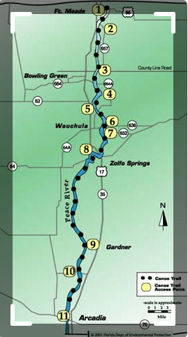

The 106-mile Peace River flows south through Polk County into Charlotte Harbor. Sixty-seven miles has been designated as the Peace River Canoe Trail, but many paddlers—like us—opt for the 31 mile-long wilderness section from Zolfo Springs to Arcadia. Few roads intersect this part of the river, and this stretch feels isolated and remote.
We launched from the public boat ramp in Zolfo Springs on a pleasantly warm Florida December day. I left my car downstream in Arcadia at the Canoe Outpost, and they shuttled me back to Zolfo Springs in their school bus. They provided detailed maps and descriptions of where we could—and could not—camp for the next two nights. In general, the right side of the river was fair game, while the left side was off-limits beyond gathering firewood. The Canoe Outpost owns several sites along the river that offered campground-style camping, but we wanted to camp more primitively. Just in case, paddlers needed a reminder, a sign in the bus warned people that they were entering the ‘True Florida,’ the kind that will hunt you down and eat you.

When I returned to the launch, Janice and Jill had loaded the boards with our camping gear, food, and water. After a few adjustments, we set off. We knew we would have some company on the river. A Boy Scout troop from Palm Beach was preparing to launch their aluminum canoes and would paddle the same stretch as us.

We aimed for about 12 miles our first day, about 7 miles upstream of Gardiner. The last third of our trip—between Gardiner and Arcadia—was more residential and offered fewer camping opportunities, so we planned our mileage to stay in the wilderness section as long as possible.

Paddling this section felt blissfully remote. We heard no road noises, and only the occasional mooing reminded us of the ranch land that border the Peace. The drive from Tampa to Zolfo Springs on central Florida’s rural roads suggested a similar isolation, or perhaps desolation, as we sped through miles of Mosaic phosphate mining.
Mosaic’s mining activity has contributed to lowered water levels in the Peace River. We checked the link provided by the Canoe Outpost site to confirm that the water level was high enough for our trip. Water levels matter even more for paddleboards than canoes and kayaks. Submerged branches reach out and grab the fin, resulting in unplanned swims.
The river meandered through a scrub landscape, alternating between straight sections and hairpin turns. The low water level exposed the limestone structure of the riverbanks, making us aware of Florida’s permeable geology. The river was so still in places that it was difficult to distinguish the landscape from its mirrored reflection. Only the leaves floating past revealed the river’s current.


After several hours of paddling, we found a perfect sandbar campsite. Since the Boy Scouts passed us in their canoes, we hadn’t seen anyone else on the river.


Firewood was plentiful enough on the sandbar for both an evening and a morning fire. Coaxing a fire from the previous night’s embers makes me glad for the skills I developed and later taught at Camp Green Cove.


The day warmed up, and we set off downriver towards Gardiner. The day before, we saw a number of baby gators basking on the riverbank, but downriver, the mama gators were out and about. Not a good place to fall off the board.

And the birds: ibis, egrets, bob whites, great blue herons, wood storks, and roseate spoonbills. One trip highlight for me was a flock of wood storks flying overhead, with two roseate spoonbills in the mix to add a touch of color. I’m never quick enough with a camera to catch such moments, but then no picture could do it justice. Bearing witness was enough.
We paddled on, aiming to camp downstream of Gardiner. We passed a run-down cabin, with several men sitting outside. One waved, but wordlessly we quickened our pace, as banjo music invaded our imaginations. Several miles down, a sandy bluff welcomed us for the night. Long after we had set up our tents, we discovered a dilapidated abandoned house nearby. Fortunately, it didn’t look like anyone would be returning soon.


On our last morning we paddled the final stretch through a residential area and past Canoe Outpost’s Oak Hill Campground. A number of people were sifting through the sand in search of shark’s teeth and other fossils, a draw for many Peace River paddlers.

 Canoe Outpost — Peace River
Soon we arrived at the Canoe Outpost in Arcadia. Janice and Jill continued onto the the public boat ramp about 1 1/2 miles downstream. The outfitters not only helped me load my board onto my car, they also washed it!
Janice and Jill looked a bit stunned when they arrived at the boat ramp. They had seen Amphibious ATVs plowing through the river just upstream from the ramp. Who knew?
As we loaded the car, our minds had leapt ahead to the tacos at Chuey’s Taqueria and Ice Cream in Zolfo Springs. That meal alone is worth a return visit.
This 31-mile section of the Peace River is a perfect 2-3 day paddleboard camping trip. Depending on water levels and river conditions, paddling the upper sections would make a longer trip. While paddling down the Peace River, it’s hard to believe that we were close to some of Florida’s most populated regions. But, Florida’s waterways, once our highways, offer us our best chance to experience wilderness.


