There is No Magical Place Called Away

I am reposting the blog I wrote for Exxpedition, an all-women’s sailing and research team exploring solutions to marine plastics.

http://exxpedition.com/2016/02/26/there-is-no-magical-place-called-away/
After several days at sea, the crew of the Seadragon disembarked in Bridgetown, Barbados. Our sail from Trinidad was rough, and we were excited to stand on solid ground and to meet fellow environmentalists in Barbados. We had arranged two days of meetings with schools, universities, and Bajan environmental organizations to share concerns about marine plastics and their effects on marine and human health. Although eXXpedition is a sea-based mission, these face-to-face conversations, to me, became the most important and interesting part of our trip. After all, the plastics that litter the world’s oceans come from the land, so our solutions, too, must be land-based, and we need to work together across borders to save ourselves and our seas.
The Seadragon had reached Barbados two days earlier, our 72′ sailboat dwarfed by the cruise boats, tankers, and container ships anchored in the island’s small port area. Once unpacked, these ships disgorge the thousands of plastic bags, wrappers, and bottles that pass only briefly through human hands on their way to landfills and, worse, the sea. Marine scientists had presumed that these plastics amass into enormous plastic islands, floating in perpetuity in 5 separate oceanic gyres. However, more recent research suggests that these plastics disintegrate into micro particles that migrate back from the ocean into our bodies. For the two previous days, in between bouts of seasickness, the crew had trawled Bajan waters to find traces of these micro particles.

We anchored in Carlisle Bay, and our skipper Shanley ferried us by dinghy to the public dock near Independence Square. From there, our tight knit group split in two and headed in separate directions. One group met with primary and secondary schools and representatives from Marriott hotels, and my group made presentations at the University of West Indies at Cave Hill and Lockerbie College. That evening, we reconvened for a brainstorming session with the Future Centre Trust and representatives from local environmental groups.


Seadragon


We told stories about our successes and failures, our victories and frustrations. We commiserated about non responsive governments and friends who turn a blind eye to debris. In particular, we discussed the difficulties of creating a cultural shift, making reusable bags and cups the norm. One of our Bajan colleagues commented that “There is no magical place called away”–our plastics essentially last forever, in the oceans, on land, and now in our bodies. We shared strategies and successes in motivating our own communities to reduce their plastic use. Most important, we came together–Bajans, Americans, and Europeans-as peers to navigate towards a cleaner future.


Ocean toxicity is a wicked problem, meaning that the problem is complicated, with no single cause and no single solution. Some of the best responses will be local and grass-roots, emerging from the specific skills, cultures, and values of different communities. It is not a matter of telling people what to do. After long histories of colonialism and overbearing development agencies, it’s time to listen, strategize, and collaborate.

In addition to our meetings and presentations, we had scheduled beach clean-ups in both Trinidad and Barbados. At first, I wondered if these events weren’t just some feel good exercise, but instead these clean-ups gave us more time to talk in more depth with our hosts. On both islands, we literally got our hands dirty, picking up bags and bags of trash with gloved hands, and learned about the challenges specific to each island. In Trinidad, over 35 people came to the cleanup, having only 2 days notice, and we met people dedicated to sea turtles, trash, and clean water. In my own fieldwork, that’s when the best conversations come–working side by side, not in formal interviews.
This collective brainstorming reminds me of what Mark Juergensmeyer refers to as Gandhi’s third way–in a dialogue or conflict, listening to others, hearing their concerns, and working to address those concerns can produce answers better than any of the parties initially proposed. To move forward and solve this wicked problem, we need ideas and solutions from multiple religious and cultural viewpoints, disciplines, and professions.
We all own this problem now. The magical “away” is now our bodies, and everybody suffers as toxics leach into human and animal bodies. Although the burden falls even heavier on those with less access to clean water and health care, nobody can buy their way out of this problem. Women’s health, in particular, will be affected because these toxics are endocrine disrupters which means they disrupt hormones. Removing large plastics such as bottles is one thing, but removing disintegrated micro plastics seems a Sisyphean task.
The opportunity to work on a sailboat and collaborate with others drew me to join eXXpedition, but some of the most gratifying moments have been on land. We set sail tomorrow for St. Lucia where most of us will disembark and return home. The Seadragon will sail northward with a new crew, but I am confident that the bonds and friendships forged in our short time together will help us continue the work that brought us together.

TRAK Unleashed: PADDLERS IN PARADISE

In honor of Valentine’s Day, here is the blog I wrote for Trak Kayaks about our kayak camping trip to the Exuma Islands in the Bahamas. Hopefully we will take the Traks back to the Bahamas in 2017.

By Whitney Sanford. All images ©2014 Whitney Sanford and Kevin Veach used by permission.

After the motorboat drove off, leaving Kevin and I, our boats, and about one hundred pounds of gear off on Big Major Cay (near Staniel Cay), we were on our own for a honeymoon paddling and snorkeling adventure in the Exuma Islands in the Bahamas. This was day 1 of a six-day self-supported kayak trip from Big Major Cay back to Barreterre, where we had started. Although we had done several self-supported kayak trips before, the remoteness of this trip called for new levels of teamwork and flexibility; we were each other’s back up and safety.

We had brought our TRAK kayaks and paddling gear from the US and then rented stoves, camping gear and a local cell phone from the Out-Island Explorers. Our shake-down trip through Florida’s 10,000 Islands demonstrated just how much the boats…

View original post 950 more words

Losing Cannon Springs

River withclopuds2.jpg
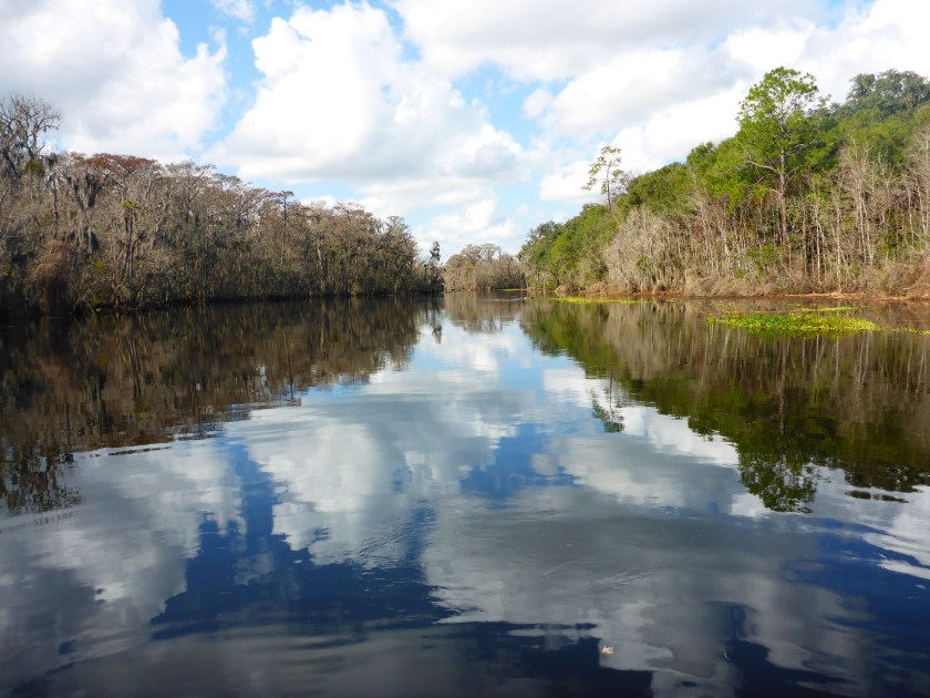
Twice last week, I swam in the blue waters of Cannon Springs. I brought my mask and snorkel so I could see the vent and the fish that swam in the hole. Even from the shore, I could see fish in the spring—the water was that clear. The entire Okhlawaha River is beautiful, but its hidden springs are gems that are worth working for. I had paddled south from the Payne’s Landing entrance and north from Eureka West to see the different moods of the river – the twisty s-turns closer to Eureka straighten out as the river widens on its northward course.

verticaltrees.jpg

I wanted Liz, my fellow adventurer, to see the Okhlawaha River in its lowered—or natural—state, and especially I wanted to show her Cannon and Tobacco Springs while we had the opportunity. I had told her about swimming in Cannon and tromping up to see Tobacco Springs and knew she would want to do the same. After our shuttle, we pulled her kayak and my paddleboard to our launch—which had significantly more water than it did several days ago. I had heard that the water was up, that they were releasing was from the Moss Bluff dam, and from the shore, the flow did seem faster. We shrugged and pointed downstream, loaded with masks, snorkels, and snacks.

As we floated, I tried to point out the features that Karen Chadwick, boat captain for North Star Charters, had mentioned on my previous trip. We had seen wooden remnants of a steamboat launch, one of the 96 landings on the 135 miles along the trip from Palatka to Silver Springs.Okhlawaha.png

When steamboats traveled the river, there were launches almost every mile, dropping off and picking up lumber and other supplies. The St. Johns and the Okhlawaha were once Florida’s highways, making travel possible before roads penetrated the swamps and forests.

Screenshot 2016-02-07 20.03.46.png
File photo, Ocala Star Banner

I love looking at maps and charts, and considering rivers as highways ‘flips’ my perspective on maps. When I want to get from one place to another, I search for roads or maybe trails if I am hiking or biking. Before roads penetrated the swamps, though, land travel was difficult, if not impossible. Most people traveled by boat, so the waterlines on the map—not so much land features—are critical. So, the borders, the intersections where land meets water, those draw my eye because those spaces allowed the interaction of people and place.Screenshot 2016-02-07 20.02.27.png

As we floated downstream towards Cannon, I kept wondering if we had missed the spring. The river seemed slightly different, more swollen, and disorienting. Even the gators seemed larger, and we saw several who did not seem afraid of us. In fact, one swam along with us which was not reassuring on an inflatable paddleboard.


When we reached the entrance to Cannon Springs, I realized how much the water had risen. Only three days before, the spring run was clear, but now it was tannin-colored, and water flooded over areas that had been dry land. We paddled upstream towards the spring and met Karen, Margaret Tolbert and Javed coming back down, their kayaks loaded on Karen’s skiff. Margaret and Javed had been drawing and painting along the river that day. They shook their heads as we passed by. Cannon springs was now brown, its brilliant blue drowned out by the incoming water. I was sorry that Liz did not get a chance to see Cannon in its blue state.

On March 1, the river will start to rise again to flood stage as the Rodman drawdown comes to an end. The Rodman/Kirkpatrick dam will again create the Rodman Reservoir or Lake, and the banks along the Okhlawaha where I saw fisherman, birds, and gators will be submerged for another three to four years.lotsofegrets.jpg

The Rodman Dam was initially built as part of the larger Cross Florida Barge Canal project. The Cross Florida Barge project was stopped in 1971, in large part by efforts of Marjorie Harris Carr, and Cross Barge area has become the Marjorie Harris Carr Cross Florida Greenway. The Rodman Dam, though, has remained in place, a point of controversy between groups who want to restore the river’s natural flow and those that want to maintain the reservoir.

desolation.jpg

Even if the Okhlawaha River were restored to its natural flow, the land needs time to heal. In constructing the aborted Cross Florida Barge Canal, giant crushers rolled along the banks, uprooting trees and shredding the landscape. Landowners along the river lost their property and never regained access to their land, even after the project ended. Today you can see the ruins of the Strange house, now on Greenway land, and imagine the wonderful view of the river they must have had.Lizinhouse.jpg

Slightly downstream of the Strange House lies Payne’s Landing, yet another reminder of loss and heartbreak. In 1832, the representatives of the Seminole and the US Government signed the Treaty of Payne’s Landing in which the Seminole would leave their cattle, relocate to Oklahoma, and received compensation after resettlement. By all accounts, many of the chiefs were bullied or tricked into signing the treaty and refused to leave Florida, a chain of events that led to the Second Seminole War.

We took out at Payne’s Landing and reversed our shuttle. Despite the flooding of Cannon Springs, the day was spectacular, a sunny winter day in Florida, and we were happy to be on the water. Most people are happy at the take-out, and they should be. Whether fishing  or paddling, a day on the water is usually a good day. Nonetheless, there are somber undertones — Payne’s Landing, the crushers, and the incipient re-drowning of this landscape makes me think about the river’s history and the people who have called this home.

Searching for—and Finally Finding—Cannon Springs

riverand clouds3 copy.jpg
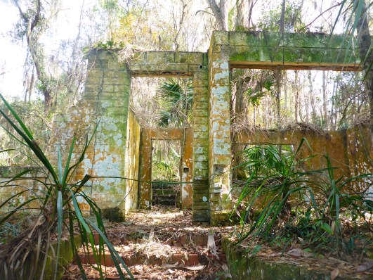
I had started to wonder if Cannon Springs and the Okhlawaha River was going to be my holy grail. Starting in September and lasting until March 2016, the Rodman reservoir on the Okhlawaha River is drawn down, the river-lake levels lowered substantially. This draw down occurs every few years—to prevent fish kills and reduce the vegetation that obstructs the water—and exposes the natural flow of the river.  The lowered levels on the Okhlawaha River offer us a glimpse of the past and a future that could be—without the Rodman Dam. I was especially interested in seeing those springs like Cannon that reveal themselves only during these periodic drawdowns.cspring4 copy

My first attempts to get on the river resulted in a series of major errors—locking the keys in the car at the remote Kenwood boat ramp, battery-less GPS and camera, and less than complete information about boat ramps. (I am now my own case study in fieldwork errors for my Religion and Fieldwork class.) As more and more spectacular pictures adorned my facebook feed, I was even more determined to see—and swim in—Cannon springs.

Finally, I made it—twice in one week. Armed with the GPS coordinates, my husband Kevin and I found the elusive put-in across from Payne’s Landing. We turned down a sandy road, lined with ‘NO ATV’ signs, and bumped our way through the small Hog Valley community towards the river. We launched and pointed our boats upstream. The entrance to the Cannon Springs Run was approximately one mile south of Payne’s Landing, and the entrance had been described as ‘unmistakable’, a tree-lined clear passage. I was also hoping to find Tobacco Springs situated between Payne’s Landing and Cannon Springs.

The river at Payne’s Landing is broad with an expansive vista. Several fisherman sat on the east side of the river, where the draw down has exposed the beach. The day was overcast, but warm, a seemingly auspicious start to our journey.  Some parts of the shore had healthy trees that have survived the flooding, while other patches revealed the desolation of a dying landscape.

2016-01-26 12.20.26.jpg

Heading south, we heard shots which continued for about 15 minutes—target practice, we assumed, so we paddled on, but a bit unnerved. Soon after, the batteries in both the GPS and the camera failed. Three inauspicious signs, but we kept going. We settled into a rhythm against the slight downstream flow and saw woodstorks, ibis, egrets, and a variety of herons—and of, course, gators.

We paddled mostly in the center of the river, avoiding the vegetation near the banks where gators like to hide. Kevin paddled into the vegetation once and heard the unmistakable splash of a startled gator. After about half a mile, the wide river narrowed into a series of s-curves, and dark lines on the trees along the bank told us what has become the new normal for water levels— the flood stage caused by Rodman/Kirpatrick dam. lines copy.jpg
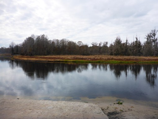
Finally, we spotted what had to be the entrance to Cannon Springs. Everyone said that the entrance to the Cannon Spring Run is unmistakable—a tree-lined corridor, and they were right.

cannontunnel3.jpg

The water cleared quickly as we paddled up the short spring run. First we saw several vents that are part of the larger Cannon Spring system, then the blue spring itself.  The spring is relatively shallow so the vent is visible. I pulled out my mask and snorkel and dove into the clear water to see the vent. (Swimming in January is a major benefit of living in Florida.)


Seeing Cannon Springs once was not enough, so when I saw the Aquaholics trip down the Okhlawaha River scheduled for the following Saturday, I immediately signed up. I met the group at 9 am at Eureka West boat ramp, and after shuttling cars to Payne’s Landing, we floated downstream. Karen Chadwick, boat captain for North Star Charters, joined us in her kayak for the float and offered both historical and environmental perspectives on the river and its ecoheritage. She is also Vice President of the Putnam County Environmental Council and member of Florida Defenders of the Environment has been working to restore the Okhlawaha River to its free-flowing state, carrying on Marjorie Harris Carr’s environmental legacy. As we floated downstream, Karen pointed out historical features that I would have otherwise missed and also led us to the elusive Tobacco Springs.

We saw a number of milled logs, remnants of the days of logging the surrounding forests. She also pointed out the wooden remnants of a steamboat launch area. When steamboats travelled the river, there were launches almost every mile, dropping off and picking up lumber and other supplies. The St. Johns and the Okhlawaha were once Florida’s highways, making travel possible before roads penetrated the swamps and forests. Just a few wooden remnants are visible now. steamboatlaunch2.jpg

Then, finally, Tobacco Springs! Kevin and I had looked for it, but never found it. Not surprising – the spring run was clogged with water lettuce. Our group of intrepid kayakers (and my paddle-board) pushed our way through the vegetation until fallen trees blocked our path. We dragged our boats onto the bank and walked a several hundred feet through fairly dry muck. The spring was worth it – deep and not as clear as Cannon Springs, but full of fish. We peered down into the spring from the ruins of an old dock. None of us dared swim here, given the possibility of alligators in the cave below.


Just beyond Tobacco spring, we explored the ruins of the Strange house on land that is now part of the Florida Greenway. Dr. Strange built a house on the Okhlawaha River, complete with pool, patio, and river-front view. The family lost access to the land during construction of the never-completed Cross-Florida Barge canal. Tragically, Dr. Strange and his grandson were killed when their truck rolled into the river.strangedoor copy.jpg


I found my grail – Cannon Springs and Tobacco Springs, gifts from the current drawdown. I hope to get back out again soon. Karen said that the river has already risen, and starting on March 1, 2016, the reservoir will continue to fill, rendering these springs almost imperceptible. The exposed beaches will be submerged again, drowning nesting areas for birds and turtles. I’d like to paddle this section of the Okhlawaha River again, just to see what it is like when the water floods again, but I have a feeling that I will be disappointed. River withclopuds2.jpg

%d bloggers like this: