What Practicing Kayak Rescues with the Coast Guard Taught Me

Lowering rescue swimmer
Coast Guard helicopter lowering a rescue swimmer

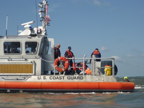
Mayday, Mayday, Mayday…These are words I hope never to say, but there I was in Charleston Harbor hailing the United States Coast Guard. I pulled my marine VHF radio from my PFD, or life jacket, and requested medical assistance for a 62-year old male with chest pains and dizziness. Fortunately, this call was only part of a training exercise. The designated victim—my husband—played the role of victim in our rescue scenario. Nevertheless, seeing my husband stretched out on the deck of a 45′ Coast Guard Response Boat Medium reminded me that someday one of us might need to make a similar call.

P1030273
Medical care for “Victim” Kevin

Kevin, myself, and five others came to Charleston to participate in a kayak-Coast Guard training exercise. Every April, Scott Brown and Jeff Atkins run the Joint Incident Management Program prior to the East Coast Paddle Sports Festival. Scott is a retired army officer and helicopter pilot who conducted combat search and rescue exercises, and Jeff is a kayak instructor and park ranger in South Carolina. Scott designed this exercise to help the coast guard and paddlers partner in real rescue situations, so the training works both ways. Kayakers learn the correct language to hail the coast guard and guide the rescue boat and helicopter to their location, and the coast guard personnel learn how to locate and assist people in small boats.

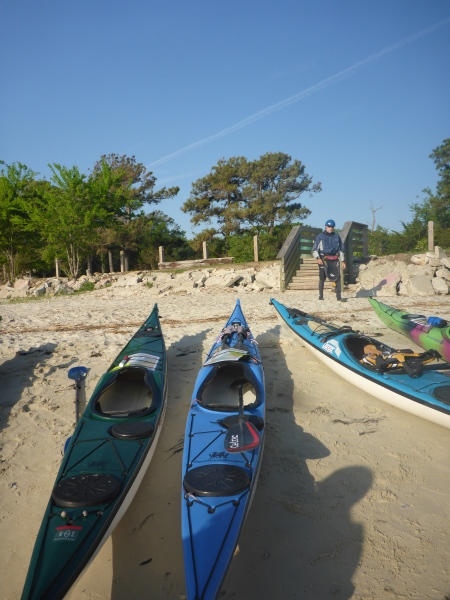
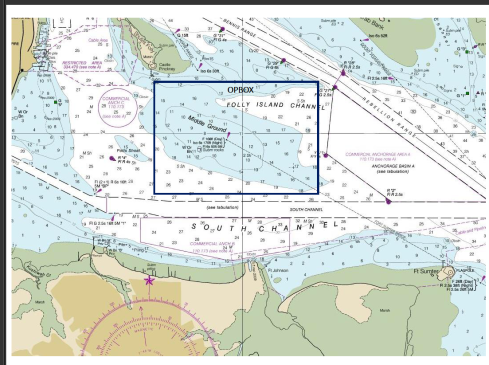
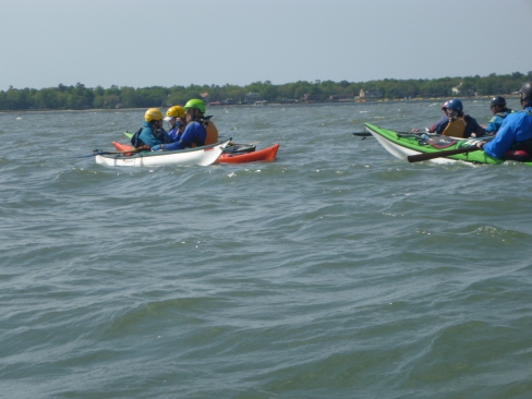
Our team of nine gathered in Demetre Park gathered at 7:30 am on a windy morning. Several days before, we ‘met’ on a conference call to go over call signals, safety protocol and the morning’s program. I had been checking wind and waves daily, hoping conditions would be small enough to conduct the exercise but big enough to be somewhat realistic. As soon as we arrived, we prepared our boats and gear to launch in case the weather deteriorated. Everyone carried VHF radios, tow belts, contact tows, and a variety of rescue and safety equipment, including extra clothes and first aid kits. We paddled out to a day mark, a navigational marker, in the area of ‘Middle Ground’ between Castle Pinkney and Fort Sumter, to prepare for exercises with the coast guard boat and helicopter.

Middle Ground
Middle Ground in Charleston Harbor
P1030299
Rafting up to create a stable platform
P1030321
Holding position in waves

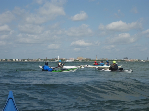
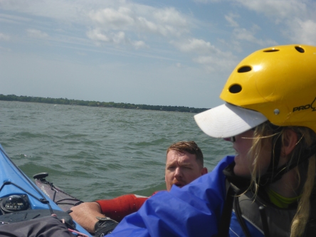
First we practiced ‘rafting up’, that is, holding our boats together. In case of an actual rescue, gathering the boats both makes us visible to rescuers and also provides stability to care for a victim and call for help. In rough conditions, a victim who is ill or has sustained an injury such as a shoulder dislocation will not be able to remain upright and needs the support of at least one other kayak. Another paddler might tow the entire raft to prevent drifting into a hazard. Kayakers frequently use the term ‘raft up’ when we want or group to come together, and I had never considered whether this term is useful to others. One participant associated with the Coast Guard pointed out the term ‘raft’ is meaningless to the Coast guard. Another wondered if they might not look for a large gray raft, not a group of kayaks. Scott warned us to avoid jargon—“Use plain language.” Lesson learned.

P1030285
Working with big and little boats in waves
P1030269
Lee stabilizing a boat

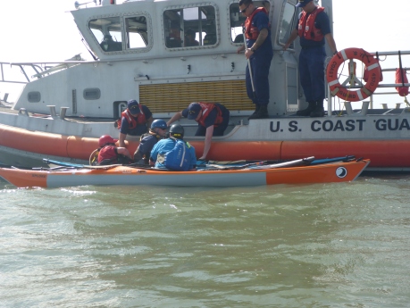
At 10 am, on military time, we began our exercises with the Coast Guard boat and helicopter. I made the first Mayday call, requesting help for Kevin’s “heart attack”. I noted our location, the number of  people in our group, and our problem. And the Coast Guard always asks if everyone is wearing a PFD. After approximately ten minutes, the rescue boat arrived—this might be much longer in a real situation. Lee and Ted stabilized Kevin’s boat and brought him parallel to the rescue boat so that he could be lifted on board. Doing so gave the crew practice working with 16’ kayaks in rough seas and helped us understand how to help the coast guard help us.

P1030385
Awaiting the helicopter

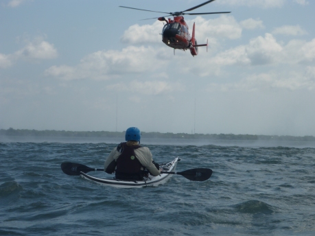
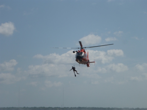
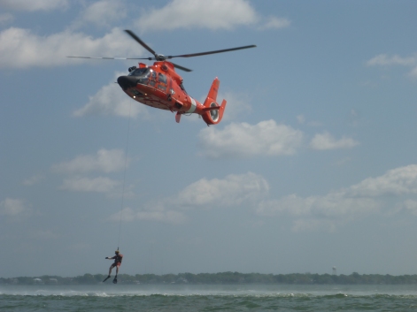
Next, the part we had all been waiting for— the helicopter ops. Imagine being injured and floating out to sea on an out-going tide. A helicopter flies overhead, but can they see you? From a distance, the bright white, yellow, and orange colors of our kayaks are specks in a vast ocean. A helicopter or boat might see the smoke from our flares, assuming we carried them, and most of us carry PLBs (Personal Locator Beacons). Search and rescue helicopters fly multiple search patterns looking for survivors, but we can increase our odds by guiding the aircraft using our VHF radios. Each of us practiced directing the USCG HH-65 Dolphin —‘right turn, stop turn, we’re on your nose,’ learning the language to best communicate with the crew. Then an Aviation Survival Technician “rescue swimmer,” with fins, snorkel, and helmet, jumped from the helicopter and swam to our boats, sharing tips on how to be spotted from the air. The helicopter crew raised and lowered him on the hoist, replicating what might happen in an actual rescue. If Kevin’s heart attack were real, the crew would have placed him in a rescue basket, raised him up, and immediately began medical treatment, probably saving his life.

P1030397
Search and rescue practice
P1030363
Coast Guard Rescue Swimmer
P1030367
Learning from the rescue swimmer

When life, limb or vessel are at risk, that calls for a Mayday. This is nothing to take casually. Asking for help puts other lives at risk, the rescuers and other victims, for example. However, in an emergency such as a heart attack far from shore or a serious injury, calling for help saves lives. While debriefing after the exercises, we debated about what situations call for a Mayday. In our second practice round with the coast guard 45’ Response Boat Medium, I played the victim, a 57-year old woman with a dislocated shoulder. Was a Mayday call necessary, we asked? As usual, it depends. If we had been surfing 50 yards off Folly Beach, then no because my friends could help me ashore and call 911. I would get medical care within the ‘Golden Hour.’ On the other hand, if we were a mile off-shore in an out-going tide, my inability to paddle would place the entire group in danger if we drifted into bigger conditions. In that case, calling the coast guard would reduce risk for the entire group and perhaps prevent a multi-victim rescue.

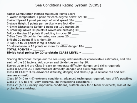
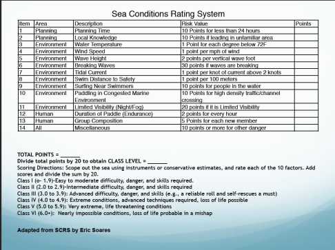
Ultimately mitigating risk is the best way we can help the coast guard and ourselves. Reducing risk begins the moment we plan the activity and does not end until everyone is home safe. This means asking questions, even ones that might seem intrusive. Is all equipment functional, and are all members of the group healthy and prepared for existing conditions? For kayakers in the coastal Southeast, understanding tides, sandbars, and currents is critical. In a incident or capsize, will we drift towards safety or out to sea? Scott adapted a set of questions from Eric Soares’ Sea Conditions Rating System. These systems quantify risk, making assessment less subjective and easier to communicate. Answering these questions helps avoid complacency, especially if we know an area well.

Scotts Adaptation of Soares System
Soares Sea Condition Rating system
Eric Soares Sea Conditions Rating System
Scott Brown’s adaptation for SE coastal conditions

Practicing with the Coast Guard was fun and instructive—everyone loves helicopters, but someday the call might be real. I’ve rehearsed Mayday calls several times, learning radio protocol in low stakes situations. I hope these drills will steady my hand and voice if one of my friends is injured or ill, when we desperately need help. My friends and I carry rescue and safety gear on our PFDs and in our boats, and we practice rescues in a range of conditions. We train for the worst and hope for the best. On any given day, you just never know what might happen, and we want to be prepared. Thanks and a big shout-out to the crews of USCG HH-65 6526 from Air Station Savannah and Response Boat Medium 45709 from Station Charleston.

P1030250
Boats and gear ready to go

Paddling Georgia’s Barrier Islands

Landing spot
Camping on Ossabaw Island

Paddling down the Bear River into St. Catherines Sound, the ocean and sky extend as far as my eye can see. St. Catherines Island to my right, or south, and Ossabaw Island—my destination—to my left. Georgia’s barrier islands hug the coast like a strand of pearls in the rough, and Ossabaw and St. Catherines are two of the finest of the string stretching from Tybee to Cumberland. Georgia’s barrier islands themselves are part of a larger chain—the Sea Islands—that extend from South Carolina to north Florida. The expanse of sea, sky, and beach give the illusion of wilderness, that my footprints on the beach are the first to land, but I know better. The sea has washed away the footprints of multitudes, including native Americans, enslaved Africans, colonial English, and, finally, the wealthy families who preserved these gems.

Ossabaw Island
Courtesy of Sherpa Guides Georgia

Paddling the Georgia coast is a bucket-list item for many kayakers, but wilderness that beckons makes the trip logistically difficult. Most islands south of Little Tybee either strictly regulate or prohibit camping, so it’s either paddling with a guide or stealth camping (not advised). So, when Marsha Henson and Ronnie Kemp of Sea Kayak Georgia invite me to join their trip to Ossabaw and St. Catherines, I said yes. Marsha is a certified Ossabaw guide, so our group was permitted to camped on Ossabaw while we learned about this biologically- and historically-rich island.


Coastal Georgia
Coastal Georgia (Courtesy of Google Maps)
Kilkenny
Kilkenny Marina
Loading boats
Loading boats on the dock


Ossabaw point
Ossabaw’s southern end

Way too early one morning, our group of seven gathered at the Kilkenny Marina in Richmond Hill. After loading our boats with four days of food, gear, and wine, we launched onto Kilkenny Creek for the seven mile paddle to our campsite. Riding the out-going tide, we paddled  down Kilkenny Creek to the Bear River which carried us to St. Catherine’s Sound and the southern tip of Ossabaw Island.

We took a break before the day’s greatest challenge—finding the creek that led to our campsite. We paddled out and around the ocean side of Ossabaw, looking for the creek. Kevin and I had hoped for some surf on the sandbar that protected the island, but the wind was calm, with little swell that day. Finally Ronnie spotted the creek near a large deadfall. Fortunately we had enough tide to reach our campsite, about ten minutes upstream.

Gator slide
Canoe launch by day, gator slide by night
Landing with kayaks
Kayaks at rest
Resident gator
Campsite gator

The ebbing tide revealed our next challenge—climbing up the slick mud bank. I found a clear patch, aka gator slide, and dragged my kayak up onto the grass. Victory—only half my drysuit was covered in mud! While the rest of the group came onshore, a small gator swam back and forth across the creek, staking claim to our launch.

Water tower
Our water supply
Drysuits
Drying the drysuits
Campsite buoy
Campsite buoy

Ossabaw Island Foundation manages two primitive group campsites for visitors, and our campsite was far from the island’s few buildings. We can thank the Torrey family from Michigan for preserving Ossabaw island. The family bought the island in 1924, and their daughter Eleanor Torrey West created the foundation in 1961. In 1978, the families deeded the island to the state of Georgia, creating Georgia’s first Historical Preserve. Several other Georgia barrier islands also followed similar gifting patterns, including Cumberland and St. Catherines. Because these islands passed directly from the families to the state of Georgia, they remain largely undeveloped, and visitors experience the ecosystem of coastal hammocks.

Campsite
Nothing says relaxation like a hammock
Marsh
Marsh panorama from my campsite

The coastal ecosystem is not shy. From the moment I stepped out of my kayak, it swarmed around my head, dive-bombing my drysuit in search of exposed skin. The gators, no-see-ums, and mosquitos made clear that I was merely a link in their food chain. In fact, shortly after my trip, actor Will Smith, filming Gemini Man on the Georgia coast, lamented that “y’all gotta do something about these bugs.”

The marshes and estuaries are biologically rich, fed by the seven-foot tidal flows of the Georgia Bight. The concave curve of the southeast coast funnels the tidal flow into the center, near Savannah and Tybee Island. Fish, clams, oysters, and shrimp thrive in the nutrient-rich mud of estuaries, nourishing birds, mammals, and humans. These islands once supported large populations of native Americans, followed by waves of immigrants from Spain, France, and England. The English, in turn, enslaved Africans for their rice plantations, favoring west Africans who had created novel techniques of tidal irrigation in Gambia and Senegal.

012-Georgia-Bight
(Courtesy of Brown’s Guides)

Today, these flows draw kayakers and stand-up paddle boarders for river mouth surf. The ever-changing sandbars St. Catherines Sound and the Back River near Tybee Island, for example, create rough water and waves that are fun for surf and rescue training. Storms and hurricanes frequently rearrange the sandy ocean floor so that surf patterns can change from one week to the next. Even islands disappear and reappear. Just last year, Hurricane Irma created an island now named Little Blackbeard. I had heard that the sandbar near St. Catherines had some of the best surf in the area, so I hoped for some waves when we crossed St. Catherines Sound from Ossabaw to St. Catherines Island. No such luck.

St. CAtherines
Lunch on St. Catherine’s
St Catherines buoy
Ripped free and tossed ashore on St. Catherines

We landed on St. Catherines, like Ossabaw, minimally developed. But sitting on the beach, none of us could have guessed that lemurs roam this coastal forest. As a child, I visited St. Catherine’s as a child and learned about the New York Zoological Society’s (or the Bronx Zoo, as we called it) rehabilitation programs. St. Catherines Island hosts several  animal rehabilitation programs as well as field schools in archaeology and ecology.

Please let there be surf on the way home, I thought. The incoming tide rewarded our patience as waves broke over the sandbar for a short surf session. We didn’t linger long — dark clouds loomed in the western sky.

Deadwood with storm
Dark clouds over an Ossabaw Boneyard
Flag
A little breeze perhaps?

The next morning, we fought a stiff wind back to the marina, reversing our journey. For several years, I’ve looked longingly across Waussau Sound, wanting to continue south towards Sapelo and  Cumberland, to learn about their unique histories and cultures. Seeing Ossabaw has whetted my appetite to see the rest of Georgia’s barrier islands.  To quote Marsha, it’s “Ossabawesome!”

716-georgia-coast
Courtesy of Georgia Coast Atlas
%d bloggers like this: