Countdown to Alaska: Kayaking the Inside Passage

img_3281
Somewhere near Homer, AK in 2016

Forty days and forty nights in a Pilgrim Expedition on Alaska’s Inside Passage? Which boat, some ask, assuming I’ve booked a cruise. No casinos, midnight buffets, or lounge chairs on the mighty Pilgrim Expedition, a 17′ sea kayak designed to handle the rough waters of the Irish Sea. Or, in this case, the Gulf of Alaska. My task: cramming food, gear, water, and clothes into my boat without sinking it.

Cruise ship
S.S. Solitude? (Courtesy of Alaska Tours.com)
Matanzas NDKs
Pilgrim Expedition basking in warmer climes

What is the Inside Passage? The Inside Passage extends over 1,000 miles from Seattle, WA to Skagway, AK. The barrier islands buffer the wind and swell from the Gulf of Alaska and create a relatively sheltered passage for boats of all kinds. The Alaska segment runs approximately 500 miles, depending on route. Many of these areas are roadless, so the Marine Highway system is essential for travel in southeast Alaska.

Alaska's Marine Highway
Alaska’s Marine Highway (Courtesy of Alaska.org)

Our plan. Our team of four (Anthony, David, Dawn, and myself) will kayak from Skagway, AK to Prince Rupert, BC, just south of the US-Canada border. We anticipate thirty to forty days on the water, depending on weather. Logistically, paddling north to south made sense. Months ago, we secured our ferry reservations from Prince Rupert to Skagway so we can paddle back to a car in Prince Rupert. David is dodging tornados driving boats and gear across the US to Prince Rupert. Dawn and I bought one-way tickets so getting home will be part of the adventure.

n1gpFzKoRqmQa+g2aAN01Q_thumb_356e
Like a jigsaw puzzle
ea+OyNUwTmKN6IbxHPK4ug_thumb_356d
It fits!

Our gear. Kayak camping always requires lots of gear, but Alaska’s remoteness and rough conditions demand even more. I’ve packed and repacked drybags of all sizes. Warm clothes, an back-up stove, and water filters. Sets of clothes for sleeping and a different set for cooking. A drysuit and underlayers for paddling. My dromedary water bags hold over 24 liters of water. Somehow it fits. Now. I’m sure there will be hard choices at the last minute.

R6JsDdLBQDWW2wNSyZMO6Q_thumb_3568
I’ve already forgotten what’s in TVP Surprise

At home, I experimented with dehydrated and freeze-dried foods and a vacuum sealer. Kevin, my guinea pig, was a great sport about testing new concoctions on our sailing trip to Flora-Bama. After a hard day of paddling, even TVP Surprise will taste fantastic. And I can’t wait to try my dehydrated Ice Cream Sandwich.

Aastronaut chow
I will savor this one night

One decision point: how much food to pack. We need to carry enough food to account for the inevitable weather delays. Many paddlers mail packages to themselves along the way, and I might do this on my upcoming hike along the Appalachian Trail. Others purchase food along the way, trusting what appears on the shelves of local stores. I decided to pack approximately half of my meals and make do with whatever I find in Juneau, Ketchikan and towns along the way. Some creative meals perhaps, but that’s part of the fun.

Culinary delights (Valero.com)

Lions and Tigers and Bears, oh my. Brown bears (or grizzlies) and black bears populate Alaska, and we are paddling through their kitchen. Bears are apparently less habituated to humans on the islands along Alaska’s Inside Passage, and we hope to minimize bear-human interactions. Our group of four is small enough to fit on postage-stamp size campsites, but large—and loud—enough to repel curious bears. On previous Alaska trip talking and singing has kept bears at a good distance. (Go away little bear..) Odor-proof bags, bear barrels, a bear-proof Ursack, and good campsite hygiene should minimize encounters. These precautions matter for our safety and for the safety of future campers and the bears themselves. We will carry bear spray but I hope to never use it.

KcBcAQFETHOvcHfG5H4Naw_thumb_356f
What’s left of my charts
Charts in drybags
Two bags of charts

From Paper charts to GPS. I hated to do it, but I cut up my charts, taking care to keep the compass rose and lat/long lines. They might look funny, but it gained me some much-needed space. I marked what remains with possible campsites and water sources. As much as I love paper charts, I also have a GPS. Denis Dwyer’s blog Sea Kayaking the Inside Passage has been a terrific resource.

clouds and water
My dream weather
ak-storm-1
More realistic

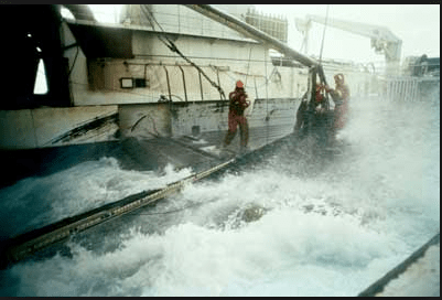
Oh for calm days and daily whale sightings, but storms and rough weather are Alaska’s reality. Think Deadliest Catch. We’ve all trained in rough water conditions and carry multiple communicatin devices, e.g., VHF radio, a PLB (personal locator beacon), and a Garmin Inreach, just in case. The weather will dictate our paddling, and I’m sure we’ll have some weather days holed up in our tents.

Screen Shot 2019-05-22 at 1.57.41 PM
Deadliest Catch (Courtesy of HowStuffWorks.com)

My boat, gear, and food is en route to Alaska, courtesy of David. I’ll have time in both Prince Rupert and Skagway to make final decisions. I’ve been prepping for months and I’m ready to go. It’s time to dip my blades in the water and launch my Pilgrim Expedition into the Skagway River.

CQMTcWTgQkCvMFnmDkXD6Q_thumb_3567
Cut-down Xtra Tuffs


Sail and SUP, Flora-Bama Style

Ingram Bayou sunrise
Sunrise in Ingram Bayou

It started with a Jimmy Buffett concert, but it became much more than that. Our Plan A: paddleboard and sail our way from Big Lagoon State Park to Jimmy Buffett’s performance in Orange Beach, Alabama, exploring the bays and lagoons around Perdido Bay. Results: Plan A slid to Plan B, then to C, D, and E. We made it to the concert, but Plans B to E brought us to people and places along the Flora-Bama borderlands that we never envisioned. And, in the end, our trip was richer for it.

Bruce Cafe
Home cooking to die for in Ponce de Leon, FL

Gainesville, FL: Saturday, 6 am. Big Lagoon State Park boat ramp, 5 pm. Storms rolling across the panhandle had already delayed our departure: Plan A -> Plan B.  Kind strangers at the Bruce Cafe helped us repair a blown bearing buddy on our trailer. Plan B -> Plan C. Finally, Big Lagoon State Park.

Early the next morning, we launched KneeDeep ll, our 22′ O’Day, and motored west through the narrow ICW to Perdido Bay. We hoisted our sails in Perdido Bay, crossing back and forth from Florida into Alabama and back again, in the light afternoon breeze.

Screen Shot 2019-05-18 at 8.19.56 AM.png
Perdido Bay region
IB KD at anchor
Palmetto Cove anchorage

So many firsts. We navigated the shoals protecting Palmetto Cove and dropped anchor…seamlessly. A happy surprise since we hadn’t practiced anchoring with this boat. I inflated my paddleboard and paddled off to explore nearby creeks. Inflatable SUPs make perfect dinghies for small sailboats.

Another first: paddling and sailing independently, navigating to a designated location. The following morning, Kevin raised the sails and single-handed the boat, and I paddled up Soldier Creek, where we met two hours later. We each carried a VHF radio and a PLB (Personal Locator Beacon), and I carried my new Garmin Inreach in my PFD. All good practice for my upcoming kayak trip to Alaska’s Inside Passage and next year’s WaterTribe Challenge.

Kevin at sail
Kevin’s happy place

The bays and lagoons around Perdido Bay are perfect for paddleboards, as described by the Orange Beach Canoe Trail. The smaller bays and lagoons, in particular, offer some protection from wind and have less tidal variation. On the other hand, as I followed the twists and turns of one creek, it sure looked like alligator territory to me.

That night, we discovered a local favorite—Ingram Bayou. Surrounded on three sides by Alabama’s forests, no buildings in sight, we slept in splendid isolation.

Ingram bayou reflections
Reflections on Ingram Bayou
IMG_2329
Kevin: a perfect guinea pig for my dehydrated experiments
Vberth
Home sweet home
View from inside boat
From inside

Jimmy Buffett Concert Day. I paddled from Ingram Bayou to Wolf Bay where we loaded my board and motored towards Jimmy Buffett. Our splendid isolation soon gave way to ICW traffic and the circus-like atmosphere of the Wharf Marina.

IMG_2349
Our slip
IMG_2343
And these weren’t even the biggest boats
IMG_2348
From wilderness to this…
IMG_2341
Getting into the spirit

By mid-afternoon, land sharks, coconut bras, and hula skirts had taken over. After I accepted a “shot” of a Bahama Mama from a shark, I knew it was time to up our game. We donned our leis and joined a jovial crowd at a pre-concert where we all sang the expected renditions of Buffett covers as well as “Sweet Home Alabama” and heard cheers of “Roll Tide”. I’ve never had a better Cheeseburger in Paradise, and, as always, the show was great.

Back to Palmetto Cove. By boat and board, we returned to our Palmetto Cove anchorage, but conditions had changed. Clouds covered the skies, and small white caps made balancing on my inflatable board difficult. That day tested both our endurance and communication devices much more than the easier days. The NOAA weather report confirmed our suspicions that we needed to find shelter for the following night. Fortunately, the Bear Point Harbor had space for us, and the next day,  we secured our boat in an inside slip. Plan C -> Plan D.

Immediately, we knew that Bear Point Harbor was our kind of marina. After an excellent (and not dehydrated) lunch in Flipper’s Restaurant, we met some of the live-aboards. In conversation, we discovered that our new friends—Captain Tinsley and Salty Scotty—docked their sailboat Salty Abandon in Bear Point Harbor. We had met our fellow parrothead sailors in the Wharf Marina and learned about their sailing adventures and the Salty Abandon YouTube channel. Small world indeed.

rICeTeE8Tnq1LtSlQ5EqUQ_thumb_3529
Setting up
oIL3EI%DQpuQT6iGxOMUdg_thumb_3522
Thank god the tiki bar is open
Sorm over bear pt
It’s here

Thank God the tiki bar is open. By late afternoon, the storm rolled in, and it was time to take shelter in the Bent Oar Tiki Bar. The evening began with their world famous Bushwacker, a milkshake with an unspecified number of rums, and only got better. Alabama Lightning rocked the house, and we danced for hours. People introduced themselves and told us about the band and life in Orange Beach.

The winds remained high the next day, and once again we revised our plan. Plan D -> Plan E: the Flora-Bama Mullet Toss, where fish fly across the state line. As luck would have it, our stay coincided with the annual mullet toss across the state line hosted by the Flora-Bama Bar, the Bama Breeze for Buffett fans.

MT arena
The arena
MT board
Scores
MT measuring
Go get your fish
Tes85dYCQzyGsVMy6i2JOw_thumb_354c
The toss
Boats at Ole river
On the ICW

Back to Big Lagoon and home. We dropped anchor just east of Spanish Point in Big Lagoon for our final night. Both shores of the lagoon offer paddling opportunities.  The Big Lagoon Kayak Trail on the north side weaves through marshes and is mostly protected.

Uli in lagoon
Paddleboard ready for action
9fv2ahxCRDmBBV8CjAWN3A_thumb_3554
Sunrise over Big Lagoon

We came to hear Jimmy Buffett and fell in love with the Flora-Bama region. The paddling and sailing was great, but the people we met made the trip. We’ll be back.

57771013679__8B9BB145-98B2-4DD2-92F8-B6671CF4E3FF
Misty morning in Perdido Bay
%d bloggers like this: