It’s that time of year. The best time of year–Matanzas! Only four more days.

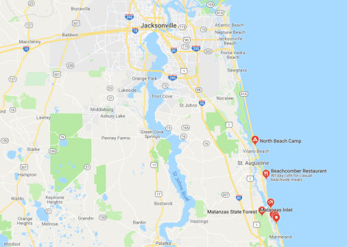
Every February Dale Williams of Sea Kayaking USA gathers his band of paddlers for a week of rough water training in Matanzas Inlet. Shaped like a ‘C’, the Matanzas River flows from St. Augustine Inlet southward to Matanzas Inlet so tidal flows and currents affect both north and south inlets. St. Augustine was the first permanent European settlement in what would later become the United States, and this historically-rich region reveals much about our past, missions, battles, pirates and plunder. But who can focus on history in the surf? As I bounce around in the chop, surf, and shoot through standing waves, enjoying the coastal chaos that river mouths offer, my world shrinks to body, boat, and blade.
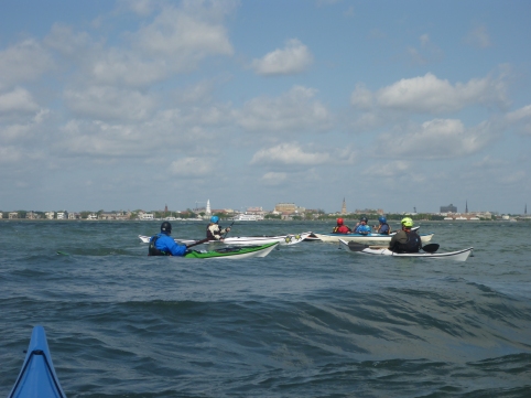
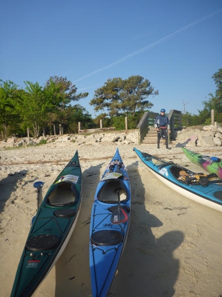
We’re paddling sea kayaks, many of us in 16′ NDK Pilgrims and Romanys, designed by Nigel Dennis from Anglesey Island in Wales. Nigel designed these boats to handle the lumpy waters, or ‘jobbledy bits’, off the coastal UK. We’ve discovered that these kayaks make terrific surf boats, and we have plenty of surf in the southeast.
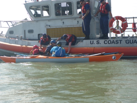
With the right conditions—swell, wind, and current, Matanzas Inlet offers near perfect waves for surfing our 16′ kayaks. Long boat surfing occupies a tiny niche in the kayak world, but the few of us who surf are addicted. Dale chose Matanzas Inlet because its shifting sandbars provide both excellent surf and a range of conditions to accommodate different skills levels. Not surprisingly, these conditions result in numerous opportunities for self- and assisted rescues.

We gather from many points in the US. The Texans, Louisianians, and Floridians among us don drysuits against Florida’s February chill, while some of the braver folks from Michigan and New England wear shorts. For them, Florida’s February might as well be summer.

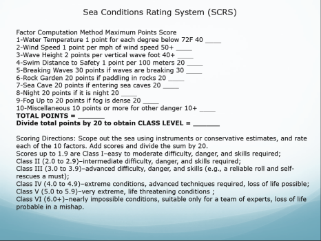
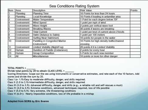
Some of us are training for the American Canoe Association’s (ACA) Advanced Coastal Kayaking Instructor Award, which requires a combinations of factors including 3-5 foot seas, 15-25 knots wind, 3-4 surf break, and 5 knots current. This means not only surviving these conditions but teaching, playing and rescuing in them. Each morning and evening, we meet on the porch of our shared house for Dale’s “academics”, where we discuss surf and rescue techniques and topics such as navigation and marine weather. By the time we reach our launch site, the day has warmed to a temperature even I can tolerate.]


An historical marker describing the 1565 ‘Massacre of the French’ marks our path through the dunes. We refer to ‘Matanzas’ so casually—”Are you coming to Matanzas this year?” Even though Fort Matanzas National Monument sits just upstream, it’s difficult to imagine that this tranquil inlet hosted such bloodshed and cruelty. The Spanish massacred over 300 stranded French mariners in this place. I’d reflected on this before, the incongruity that places of great beauty and tranquility mask bloody histories. Just north, for example, Fort George Inlet near Jacksonville was the southernmost point of the Low country slave trade.
Our schools teach a myth of origin that revolves around New England, pilgrims, and religious rebellion, but Spanish rule of Florida began in 1513, prior to any British settlements. The First Coast endured waves of French, Spanish, and British newcomers who eradicated indigenous populations, and, often, each other. In 1742, the Spanish built Fort Matanzas to guard against British incursions, and they ruled Florida until 1763. The British gained control from 1763-1783, ceded Florida back to the Spanish in 1783, and regained the territory in 1821.
The sandbars that guard the entrance to the river mouth shaped Florida history. The shallow waters of Matanzas Inlet protected Fort Matanzas and St. Augustine from British invaders, but they also led to plunder and piracy. Pirates chased ships aground onto sandbars along the Florida Coast and plundered the cargo. Wreckers, as described in Tim Robinson’s Tales from Old Florida later replaced pirates and salvaged materials from ruined boats, establishing settlements in the process. River mouths were treacherous to anything other than small, nimble boats.
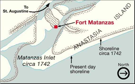
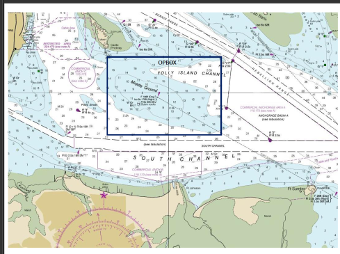
This 1742 map shows how the Matanzas Inlet shoreline has changed, which is what happens with sandy coasts. Unlike the rocky coasts of the northeast and Britain, our river mouth hydrology changes with every hurricane and every major storm. NOAA charts illustrate permanent land masses and static navigational features, but sandbars come and go, so that we re-learn our coasts after every storm.


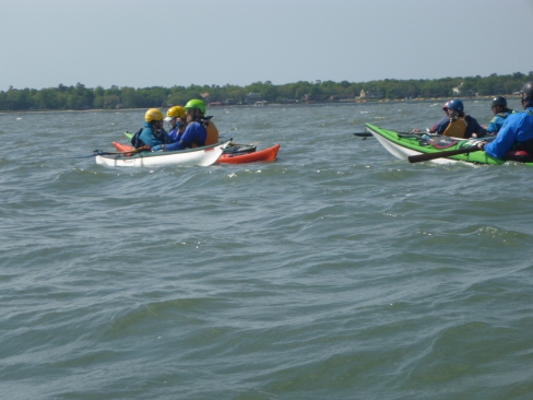
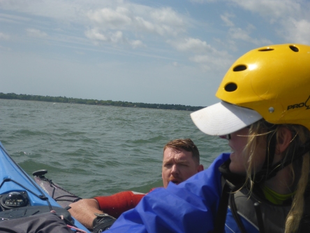
And this is why we train here. To learn how to navigate through the changing hydrology of sandbars and river mouths. Some paddlers were exploring these features for the first time, learning to brace and roll in the waves. Others, like myself, were learning to lead other paddlers, to bring groups safely through a surf zone with breaking waves up to four feet. This means not only leading groups out through waves, but bringing them back through the waves. Like climbing, it’s easier to go up or out than down or in.
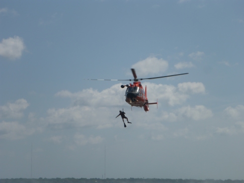
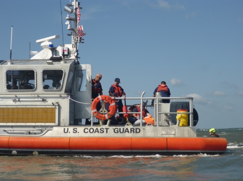
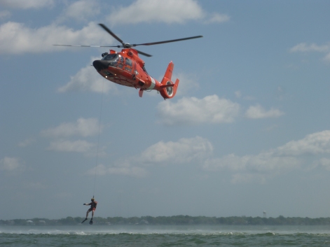
The strong tidal currents of the Matanzas River, combined with strong winds, made rescues and group cohesion difficult. An out-going tide could sweep boat, victim, and rescuers out to sea. We had some unusual challenges, one afternoon, a bank of fog descended on us, rare for Florida. This is why we practice in this venue, to be prepared when the rescues, capsizes, and out-of-boats experience are real.

On our first morning, the conditions were big, maybe too big, but the waves were clean. Dale gave us free time to play and surf as a warm up for our subsequent training. At one point, I realized that we had company—two dolphins were also playing and surfing in the waves. As they leapt over the waves, they exposed their full bodies—nose to tail, something I rarely see. It’s a gift and a privilege to play with dolphins. So, forgetting the pressures of training and the ravages of history, I surfed under the bright February sun.


 Sam claims that Bartram was the “original hippie”—embracing peace, love, and care for all beings, including other people. In Bartram’s description of nearby Six Mile Run (a.k.a. Salt Springs Run), he writes


 We heard rumors of coffee, and they were true! One building held a much welcome coffee and snack shop, which we all appreciated. A smaller unpainted building housed a weaver who spun her own wool and knitted scarves and hats. She lives on the island through the summer, until fall storms halt the ferry service. I bought a hat made from the wool of a